When I prepared for my solo trek across the Outer Hebrides, I spent a lot of time on planning my route. I was dissatisfied with the suggested routes in the only existing guidebook and the official website of the trail did not offer enough detail. So, I came up with my own itinerary and decided to walk the Hebridean Way in 12 days. This is a guide to my daily hiking stages and a few tips for planning your personal route!
This post contains affiliate links which I may make a commission from. Find out more here. My trip was supported by Vaude with gifted camping equipment, CalMac with complimentary ferry tickets and VisitScotland who covered my accommodation in Stornoway. All opinions are my own.
So, you’ve decided to hike the Hebridean Way in Scotland, but you only have 2 weeks for the whole adventure? Welcome to the team! My 12-day hike along the Hebridean Way was part of a 16-day tour de force across the Western Isles, taking in the trail as well as some other additional islands.
If you have less time, you might be better off following the suggested itineraries from the guidebook, however that means a lot of long walks and rushing across some of the islands way too fast. Alternatively, you could consider walking only the most scenic sections of the trail.
Check out my complete hiking guide for the Hebridean Way!
Dreaming of Scotland? Listen to my immersive travel podcast Wild for Scotland!

How to plan your own route
I used the Hebridean Way guidebook published by Cicerone as the basis for my route planning and also for daily reference on the trail. The book describes the trail in 10 stages with additional options for doing the route in 8 or 14 days. I, however, wanted to do it in 12 days, since I could only take two weeks off and needed 4 days to split equally between travelling to and from the Outer Hebrides and additional exploring on rest days.
It might seem obvious, but when you lay out your daily routes, remember that you are the one who has to walk the distance. Ask yourself, how far have you walked with a full backpack on your shoulders, and how far is too far? From experience, I learnt that 15 miles is my upper comfort limit when walking with a full pack. Yours might be less or higher – and that dictates where and how often you’ll stop overnight.
Check out my step-by-step guide for planning a walking holiday in Scotland for more tips.
The other thing to consider is of course, where you can sleep. If you, like me, carry a tent with you, you can pretty much stay overnight wherever you like – wild camping is completely legal in Scotland as long as you obey to the Outdoor Access Code.
If you want to stay in hostels, B&Bs or hotels, their location might have a thing or two to do with where you can stop for the night. I highly recommend to plan and book accommodation well in advance!
To get to and from the Outer Hebrides, book your ferry ticket with CalMac – the Hopscotch 8 ticket contains all four ferries you need between Oban and Ullapool!
You might also like: 10 invaluable tips for hiking the Hebridean Way
The Hebridean Way in 12 day routes
Day 1: Vatersay & Barra
14 miles / 22km, ~ 8.5 h walking incl. breaks
Shop in Castlebay on Barra
Refreshment stop at Barra Beach Hotel
Overnight at Barra Holidays at Croft 183
According to the guidebook, day 1 is the hardest day on the trail – it climbs up to the highest point of the Hebridean Way and offers a little bit of everything you can expect along the rest of the hike. It was certainly a hard day – considering that it is your first day on the trail and one of my longest (14 miles) – but overall, I actually found it very enjoyable!
A road walking section along the shore of Vatersay and the causeway to Barra was followed by a steep ascent into the mountains of southern Barra. It was raining and I could barely see a thing, but it was also exhilarating to challenge my body and mind to go on. I could not always see the next waymarker post in the hills, but pushed on and made it safely down the other side.
After a long rest at the Barra Beach Hotel (hot drinks served, no meals), I continued through the boggy moorland of northern Barra. I’d lie if I said it was easy. The ground was uneven and it took me a lot of concentration not to fall. I fell in the end, but it happened so fast and the moss was so soft, I could barely tell. I reached the road towards Ardhmor right on time to witness a plane land on Barra airport – the world’s only airport that uses the beach as a runway for scheduled flights.
The rain was picking up and by the time I reached Ardhmor ferry terminal and met my accommodation host, who had agreed to pick me up, I was completely drenched – drenched, but happy.
You might also like: The best accommodation along the Hebridean Way

Day 2: Erisakay to Askernish
13 miles / 21 km (+ 2.5 miles), ~ 9 h walking incl. breaks & detour to Dalabrog
Breakfast at Kilbride Cafe
Shop in Dalabrog (detour)
Overnight: wildcamping in the dunes near Askernish golf course
Day 2 started with a scenic ferry journey from Barra to Erisakay – on the 7 am ferry in order to hit the trail as early as possible. After leaving the ferry, I crossed Eriskay way too quickly and continued across the long causeway to South Uist. This first section of the stage is mostly road walking, but my reward was a cooked breakfast at Kilbride Cafe, which is not mentioned in the guidebook.
The rest of this section of the trail follows the route of the Machair Way along the coastline. Walking is easy unless you get yourself too involved in the sandy dunes, and the views of the sea to the left and empty farmland to the right are beautiful. Pay close attention to the blooming wildflowers around you – these “machair” plains are typical for this part of Scotland and can rarely be found anywhere else in the world.
I walked a 2.5 m detour to Dalabrog to stock up on lunch supplies and water, and settled down to wild camp in the dunes at the northern end of Askernish golf course.
You might also like: 35 things to do on the islands of Uist

Day 3: Askernish to Driomor
13 miles / 21 km, ~ 8 h walking incl. breaks
No services along the way
Overnight: wildcamping near Our Lady of the Isles statue
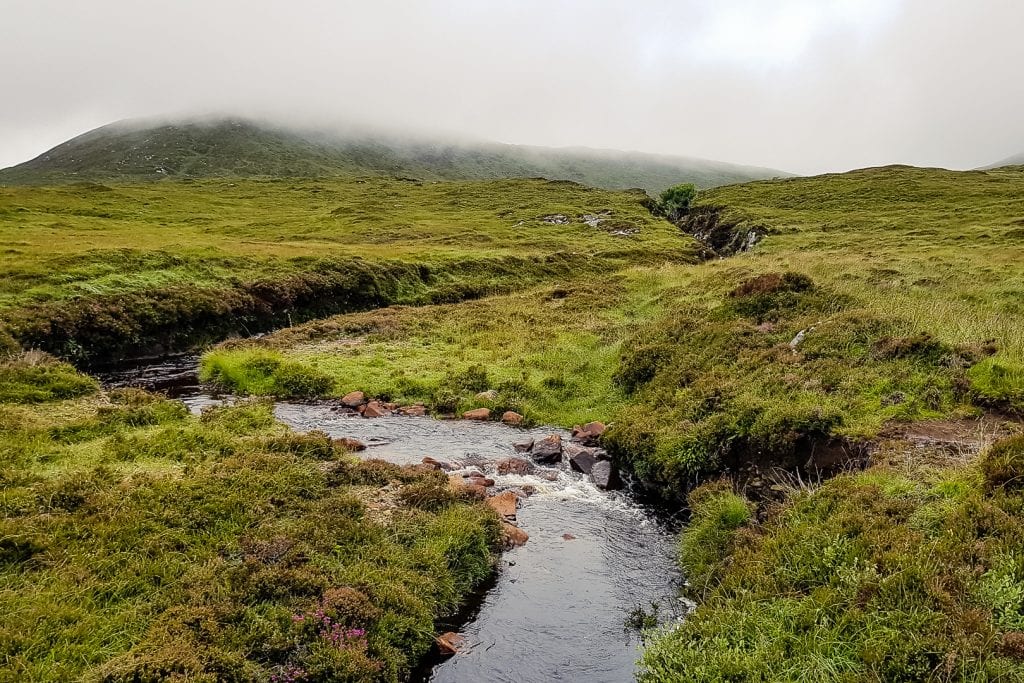
On day 3, the path continued along the Machair Way, but ran mostly behind the dunes. Without the steady breeze of the sea I was quickly surrounded by annoying black flies and a few biting cleggs. I was happy when I reached Gatliff Hostel in Howmore and could escape inside for a lunch break.
Soon after I was happy that the trail turned direction, away from the coast and towards the mountains in the east of South Uist. This was my first stint into the moorland, and the trail was in perfect condition. It was maybe my favourite section along the Hebridean Way, walking effortlessly through the purple heather, crossing lochs and standing rivers, always with the silhouette of the peaks towering high in the distance.
The last 2.5 miles of the section were road walking again, some of it on the busy main single-track road, which was not the most pleasant experience, but I soon reached my overnight stop and found a flat spot near the Out Lady of the Isles statue to pitch my tent in the wilderness once again.

Day 4: Driomor to Linacleite
13 miles / 21 km, ~ 6 h walking incl. breaks
Shops in Lovat and Creagorry
Overnight at Otter’s Edge Campsite (formerly: Shell Bay Campsite)
Day 4 was a tough but quick day. It began with a pathless crossing of more moorland on South Uist. Without a path I could only follow the marker posts across the bog, trying to stick to higher ground wherever possible. I came across some beautiful lochs and watched birds go about their daily business, but I had to push on. Once I reached the Lochcarnan Community Wind Farm (3 giant wind turbines in the moor) I followed a bumpy gravel road with inconveniently chunky pieces of gravel – a real ankle breaker!
After another wet walk across some boggy farmland, I reached the road – and would remain on it until I reached my campsite over on the next island, Benbecula. After two days of wild camping I enjoyed the opportunity to shower and wash my clothes. In the evening I went for a walk at the beach and had dinner at a nearby hotel.

Day 5: Linacleite to Carinish
12 miles / 20 km, ~ 6 h walking incl. breaks
No services along the way
Overnight at Moorcroft Holidays Campsite
Day 5 contained way too much road walking for my liking, but also one of the best views on the southern part of the Hebridean Way. Give a little, take a little.
First, I was back on the Machair Way, following once again the coastline through the burst of colour that was the machair wildflowers. After crossing Culla beach, a lovely sandy beach on the west coast of Benbecula, the path turned east once again. What followed was a strenuous 2.5 miles section of road walking where nothing much happened and the road was pretty much just straight ahead.
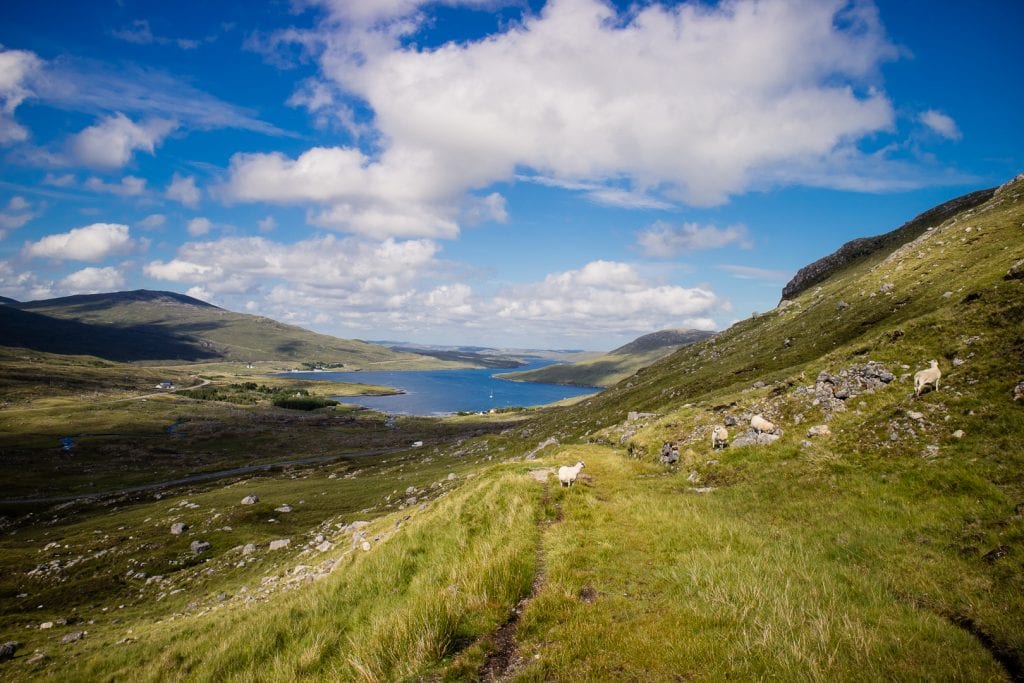
I was so glad when I finally reached the end of the road and it turned into a gravel path leading up the slope of Ruabhal, I couldn’t wait to make it to the top of this small, but singular hill. The views were incredible – I could see all the way to Skye and the mainland and even saw a CalMac ferry on her way to one of the other islands. The descent from the hill was long and tough, since there was no path, just marker posts across the boggy moorland.
The final section of day 5 follows the road once again – unfortunately the busy, but narrow main road this time, and once I made it to the Isle of Grimsay, I felt so unsafe dodging the traffic, that I decided to hitch hike the last few miles to my overnight stop at a campsite on North Uist. I recommend you do the same!

Day 6: Carinish to Lochmaddy
12 miles / 20 km, ~ 7 h walking incl. breaks
Lunch and refreshments at Langass Lodge
Shop in Lochmaddy
Overnight: wildcamping near Lochmaddy
Day 6 marked the first time I had hiked and camped for more than 5 days – and I was already proud of the achievement of having made it so far. I rewarded myself with a lazy morning and hit the trail about an hour later than usually.
Again, I had to cross a pathless moor, but the low-hanging clouds gave it an eery atmosphere that I somehow enjoyed a lot. I reached Langass Lodge, where I had hoped to stop for a warm lunch, around 11.30 am – I was pretty wet from the soft drizzle, but loved inhaling the fresh air in this remote part of the island. Since I had arrived so early, the chef could ensure that they’d prepare the soup of the day vegan, and I was happy to wait around for it to be ready.
After a very long break at the hotel, I continued along the trail and finally, the sun decided to join me! I met a fellow hiker, who was doing the southern half of the Hebridean Way in sections, and we walked together to Lochmaddy. We came past an impressive stone circle and walked along the Canadian-looking Langass Woods plantation.
Once again, there was a lot of road walking at the end of the stage, but walking together it somehow went by quicker. We reached Lochmaddy, said our farewells and I found a flat spot to pitch nearby Hamersay Hotel, where the staff was super welcoming and let me use their toilet facilities.

Day 7: Lochmaddy to Berneray
10 miles / 17 km, ~ 5.5 h walking incl. breaks
Lunch and shop at Berneray Bistro
Overnight at Berneray Gatliff Hostel
Day 7 was a short day on the trail, since I hoped to reach my next destination early enough to explore the surroundings in the evening. After an hour or so on the road leading out of Lochmaddy, I climbed around the shoulder of Blathaisbhal and found my way down through the peaty bog to an unnamed lochan below.
I found myself back on the road for a wee while, but soon returned to the empty moorland and the trail climbed almost to the top of Beinn Mhor – not that I could see much, as the clouds had finally won and I was getting wet from all sides (rain and bog – my favourite combination).
When I finally reached Loch an Sticir, I was wet and tired – in this weather I did not fancy sitting down for lunch, and so I had gone pretty much without breaks since Lochmaddy. I had 1.5 miles of road walking left before I finally reached the Isle of Berneray and made my way to Berneray Bistro. To my surprise I was soon joined by the other hiker I has walked with yesterday and he gave me the glorious idea to take the next bus across the island to my hostel for the night.
The hostel was right by the shore, overlooking the ocean, and since it was Berneray Week, me and some of the other guests headed back to the village halls for a concert of traditional songs and tunes performed by locals.

Day 8: Leverburgh to Seilebost
14 miles / 22 km, ~ 8.5 h walking incl. breaks
Shop in Leverburgh
No services along the way
Overnight at Am Bothan Bunkhouse in Leverburgh (CLOSED)
Day 8 was without a doubt the hardest for me. Initially I had planned to spend the day resting on Berneray, exploring its expansive West Beach and giving my legs and shoulders a break from the trail. But the bad weather and a last-minute opportunity to join a day cruise to St Kilda in the coming days meant, that it was beast for me to push on.
I took an early ferry across to the Isle of Harris – apparently it is one of the most beautiful ferry crossings in Scotland, but I could not see a thing through the thick foggy soup of clouds. From Leverburgh I walked along a small road into the moor and after a few miles on the tarmac, the trail turned northwest to follow the boggy “peat road” – although it was definitely generous to call it a “road” at all. The trail was made up of raised turf paths, but since it had been raining for a few days, a lot of it was submerged in the boggy, peaty soil. It took me over two hours to walk the 4 miles to Scarista.
Despite my guidebook telling me to stick to the main road for a little while, I followed the marker posts out into the dunes of Scarista beach. It was touch going in the wet sand, but I was lucky enough to bump into some friendly locals, who invited me in for a cup of tea. I was quite wet from my boggy morning adventure, so I was happy to accept – little did I know it would only get worse.
From Scarista, the trail climbs up into the hills above the coast and stayed high above the beaches for the rest of the day. On a good day, you will be able to enjoy fantastic views of Horgabost, Seilebost and Luskentyre – but I only say grey skies and thick clouds. Rain and bog were back at it again, and the more or less non-existing trail did not make matters easier. At times I lost track of the sparsely set marker posts, I nearly lost the lid of my water bottle in a small, but steep stream, and my socks felt like fresh out of the washing machine – absolutely drenched. The trail climbed up and down the shoulders of hills and took its toll on my knees.
When I finally descended towards Seilebost and coffin road to find a relatively flat and dry spot to pitch my tent, I was relieved to find a text on my phone – there was a spot for me on a St Kilda trip the next day. I stopped the first car I saw on the main road and made my way back to Leverburgh, where I splurged on a hostel and dried all my clothes overnight.
Day 9: Seilebost to Plocrapool
9 miles / 15 km, ~ 7 h walking incl. breaks
Lunch at Bays Community Cafe in Lacklee
Overnight at Minch View campsite (CLOSED)
Day 9 on the Hebridean Way might have been my favourite one. There was hardly any road walking at all and the sun had decided to come out – at least most of the day. I only had to walk 9 miles but it still took my 7 hours, because I stopped for photos often and to put on or off my rain gear even more frequently.
From Leverburgh I took the bus to Seilebost and asked the bus driver to drop me where I had hitched a ride two days before. The first section of the trail followed the ominously named Coffin Road, named so because villagers from the east coast would carry their deceased over this road to the deeper soils of the west coast to bury them. It was a pleasant walk up to the highest point and an even more enjoyable descent through the lush and rocky valley on the other side.
The Hebridean Way now followed the Harris Walkway and posts with yellow markers showed me the way. I stopped for lunch at Bays Community Cafe in Lacklee and continued through the rocky landscape of East Harris until I reached my campsite near Plocrapool.

Day 10: Plocrapool to Bowglass
15 miles / 24 km, ~ 9 h walking incl. breaks
Lunch at Tarbert Community Cafe in Tarbert
Shop in Tarbert
Overnight at Vigadale House near Loch Seaforth (CLOSED)
Even though day 10 on the Hebridean Way started with a 2-hour walk in the rain from Plocrapool to Tarbert, it became one of my best days on the trail. After I sat out the worst of the showers at the Tarbert Community Cafe with a bowl of soup, the weather turned and the sun walked with me the rest of the day.
Leaving Tarbert the trail first crossed the picturesque Glen Lacasdail – the views were fantastic. I soon joined the road near Maraig and stopped for lunch with a view at a car park along the road. The path then turned away from the road again, and while it was a little boggy at times, I enjoyed this section leading through a valley between the tall hills of North Harris. I descended towards Loch Seaforth and was left with a few miles of road walking before I reached my B&B for the night.
Day 11: Bowglass to Laxay
15 miles / 24 km, ~ 8.5 h walking incl. breaks
No services along the way
Overnight: wild-camping near Laxay
Even though it was sunny, day 11 was very hard for me physically and mentally. A strong wind was blowing, which made balancing on top of the raised turf paths across the moorland extra difficult. In the morning I crossed onto the Isle of Lewis – all it takes is to cross a river marking the border between the two isles -, walked through the Aline Community Woodland and climbed to the top of Griamacleit, a small hill with great views of what was to come – vast and empty moorland.
After a section of wooden boardwalks and jumping a locked gate that was clearly marked as part of the Hebridean Way, the trail led out into the moor and made mostly use of raised turf paths. It was easy enough to navigate, but the wind made walking a pain. The ground was still wet, and so I mostly stopped at footbridges for little snack breaks. The moor was beautiful, but pretty monotonous, and I soon got tired and bored of walking across it.
The last miles of the day I had to walk along a busy dual carriageway with little space on the sides – not pleasant! I finally decided to head slightly off trail and find a quiet spot to camp near Loch na Criadha by Laxay. I pitched my tent, had dinner in the sunset, but was soon chased inside by large clouds of the dreaded Scottish midge – the first time I encountered them on the Western Isles.

Day 12: Laxay to Stornoway
14 miles / 22 km, ~ 8 h walking incl. breaks
No services along the way
Overnight at Stornoway Bed & Breakfast in Stornoway
Day 12 was my last day on the Hebridean Way – only 14 miles were between me and my end goal in Stornoway, and I had decided to ignore the fact that 9 of those would have to be walked on tarmac roads.
I set out in the morning, full of anticipation of what the day would bring, but was soon caught up in the reality of missing or insufficient marker posts at this vital last stage of the trail. The first section of the day led me out into the moor again, crossing over to the village of Acha Mor.
After a short break to regain my strength after dodging the wet ground of the moor, I continued along the tarmac road towards Stornoway. The guidebook had promised an array of colourful shielings – small huts in the moor where farmers would stay during the summer months, overseeing their animals grazing away from the main pastures – however, most of them were derelict, colours fading or peeling off the iron sheets. Not exactly the kind of photogenic encouragement I needed on this uneventful stretch of the trail. I arrived in Stornoway with several new blisters on my feet – and they hurt. My top tip: Take the bus from Acha Mor to Stornoway and find another 9-mile hike on Lewis that is worth the effort!
The finish line of the Hebridean Way is at Lews Castle, but neither the guidebook, not the official website were very specific about where in the large park it would be. The marker posts ended as you entered the castle grounds and so I was left on my own. I walked – on more tarmac – to the small museum at the back of the castle, which is now a hotel, and asked for the way. I could tell I was not the first one.
As it turned out, the finish line was just a few minutes away, near the Woodlands Centre. Tired and exhausted I arrived – and almost started crying, I was so proud of my achievement!
You might also like: 10 things to do & see on the Isle of Lewis

In the end, I was super happy with the itinerary I had made for myself – even though I was actually a little surprised I really managed to stay on target each day. Walking the Hebridean Way in 12 days was the perfect physical challenge for me, while also leaving me with enough time to enjoy the locations I chose for overnight stays.
I hope you find this 12-day route for the Hebridean Way useful when planning your own adventure!
Pin this post for later:

Hello,
I just finished the Hebridean Way and wanted to say a big thank you for this itinerary, I used it as a reference for my own 12-day trip. I even stayed in some of the same campgrounds (though some are closed down), and I actually put my name on a waiting list for a St Kilda trip after reading here that was an option and ended up getting to go at the same point in my trip you did! There are still too few resources for this walk so just wanted to say thank you for this, I even ended up listening to your podcast episode about the Hebridean Way while looking for info without realizing it was you.
Thanks again!
Hi Lizzy, thanks for your message – I’m so glad my guide was useful for your adventure! Time to update it I guess 😅 Great you got to go to St Kilda!!! Cheers Kathi
Hi Kathi
Thank you for sharing your wonderful hike.
I’m planning to do it in mid July. I have plenty of time so I’m not in a rush. The only issue I have is “fear of heights … ” mainly walking on exposed cliffs, or along steep slops … however if the path is wide enough (like for a car to path) it is ok for me.
I have done the “West Highland Way” with no problem.
Can you please point out if there are places I should avoid?
For example: What about the first day on Barra mountains – Should I take to road shortcut?
Many thanks
Oron
Hi Oron, there are no ridges to walk on this hike at all. In the Barra hills, you walk up a steep mountain side (not unlike the Devil’s Staircase, but less of an obvious path), but there’s no sudden drop on the side. I wouldn’t say there are any places where fear of heights should be a huge issue!
Hi there! Wondering if you might advise: I am beginning to book my Hebridean Way walk for this summer and I am curious if inter-island ferry crossings for walk-on passengers must be booked in advance (do these book up easily?), and/or if they allow date changes to pre-booked tickets? I am wondering if my route itinerary can be modified a bit once there should I choose to take longer or shorter for certain sections, or if I would need to ensure I maintain my pre-booked ferry reservations? Thank you!
Hi Cora, I did not book these in advance and wouldn’t think that the inter-ferry islands require it for foot passengers. Just the ones to/from the Outer Hebrides from the mainland!
Super helpful, thank you! One last question for you (I think) – I had planned to hike this the end of August. I also have the option potentially to switch to mid-September. I am considering due to the notoriety of the summer midges in the area. Which month did you hike and do you think September would be significantly reduced in midges enough to switch my dates? Thanks for your continued first-hand knowledge!
I don’t think it would make much of a difference. It depends so much on the temperature and so how much it has been raining the previous weeks. I went in July and barely had any midges because we had a 7-wee dry spell, so there was very little standing water for them to breed. I had lots of horseflies instead which are arguably worse 🙈 It’s a bit if a gamble…
Hi there –
I too turned to the Cicerone guide book and I too found myself hoping for a 12 day itinerary option. So pleased to have come across yours to reference – thank you for sharing!
Slàinte Mhath!
Cora
I’m so glad my itinerary helped and that I’m not the only one needing an in-between solution. Have the most amazing time on the Heb Way!!
Hey,
I was at first planning to go on the West Highland ways, but I feel more and more attracted to the Hebridean ways. For those who did it, would you say it’s okay to do it as a first long distance hike with wild camping? I do a lot of hiking in the Swiss mountains, and I already did 80-90 km on a 4 days hike, but where I was staying in huts (so I wasn’t carrying as much). I would be solo-hiking, and I’ve never been to Scotland. Thanks for your answer.
Hi Lorraine, I wouldn’t exclude it as a trail for first timers. The elevation isn’t too intense and the path is well waymarked, but you do have to either carry camping equipment and be prepared to walk very long sections between villages with hostels, hotels or B&Bs. The WHW is definitely easier logistically, but you just have to prepare accordingly!
Thank you for this! I’m glad I found your post! I’m in the final stages of planning my own trip, I’m also a gal doing it on my own and I was so relieved to read about you camping as the only bit that concerns me is finding decent land to camp on if much of it is boggy!
Yay, have a fantastic time! I think Harris is the trickiest for camping because of the ground – I feel like it’s either boggy or rocky. But it’s not like you’ll be sleeping uncomfortably everywhere 🙂 Enjoy the Heb Way!
Pingback: Christmas Bonus: 'Tea and Beans' - Isle of Harris - Wild for Scotland
Thanks so much for sharing your story. There seems to be a lot of comments on the trail that say don’t go without a compass or a GPS. Did you use either to find your way?
I had paper maps and am pretty sure I would have carried my little compass with me – but I never had to use either for navigation. There are signposts marking the trail – sometimes they are a little far apart, but in general, it’s easy to follow!
Amazing blog, really lovely to read, thank you! I’m planning to walk the Hebridean Way in May and was wondering whether you could give me some advice? The stove I’ll take with me is a spirit burner, from your experience of the shops on the way, do you think I’ll be able to find methylated spirits on route?
Hi Mhairi, thanks for your comment. Amazing that you are planning to do the hike! I would imagine that you can get that kind of gas along the road – particularly the smaller independent shops as well as mechanics/garages; maybe not at the Coop! I had a gas stove with the small round gas bottles and I actually brought plenty for the whole way with me on the ferry, so I didn’t have to worry about that too much… Hope this helps!
Hello. It was really interesting to read a different version of the walk to the guide book. Me and a pal are planning to go as far as Lochmaddy for summer and I wanted to ask you how you got on with finding fresh water. Is there plenty along the way? If we could avoid having to carry loads of it it would be great weight off, but equally don’t want to risk not finding any. You’re experience on this would be much appreciated!
It really depends on whether you camp or stay in accommodation where you can fill up your water – I did a mix of both. You can fill up your bottle in most stores and shops, restaurants and cafes – and there are plenty on the way or just slightly off route. On Lewis I even asked people who were out in their gardens, if they’d fill up my bottle and they were happy to! When camping I always had about 2l with me during the day and made sure I’d be able to fill up before setting up camp. Hope this helps 😀
Hi Corinne,
It was so nice to meet you in Howmore and Linicleite two weeks ago. Hope you enjoyed the rest of your walk to Lochmaddy. How are you? I arrived in Stornoway last Saturday just in time for the last day of the HebCelt festival :-).
A note concerning drinking water for everyone who’s interested: As soon as you enter Harris it gets much easier to find fresh water in streams since the island is much more mountainous than the southern ones. There are basically no fresh water streams to be found on the southern islands along the Hebridean Way and you should fill up your water as described by Kathi. Or you could filter and treat the water from the many lochs along the way but that’s something that I wouldn’t have dared to to since the water didn’t look very drinkable at all.
Happy hiking,
Martin
What an insightful blog. Well done. I hate road walking but it seems to be an necessary evil on this trip. myself and another oldie are doing this in April. Just booked it so very excited. Thanks for all your tips.
Hi Kathi,
Thanks for your very helpful blog – it looks fabulous. I am planning to hike it in June this year. Did you find the Cicerone guidebook enough on its own to find your way? Also, how cold did you find the evenings when you were resting? Would you recommend a down jacket? – Many thanks Alice
Hi Alice, great decision to walk the Hebridean Way 🙂 The guidebook was good, but the maps in it are very small – not really useful for navigation. The trail is waymarked (usually quite consistently), but I still carried maps with me for route planning. Every evening I’d look at next day’s route, identify potential stops for breaks, look at the terrain and inclines to expect, and check for water sources. Unfortunately, there is not one handy map for the Hebridean Way (yet) so I carried all the necessary OS maps with me, which is quite a lot… Regarding clothes, I have a brief packing list in this post: https://watchmesee.com/blog/the-complete-hebridean-way-hiking-guide/ and a complete guide to my trekking packing list here: https://watchmesee.com/blog/packing-for-long-distance-hiking/. I brought my Fjallraven padded jacket for the evenings and thought that was more than enough with a fleece underneath. Hope this helps! Kathi
Thank you very much for this guide. I’m walking the Way in December and this really helps.
Hi Bill, enjoy your trip – I hope you get fairly decent weather. The landscapes must be beautiful in winter!
Hello Bill
I would like to do the Hebridean way in december and i would like to know how this was for you in december even if it is a long time ago ! A lot of people tell me that it is too much windy in december. I would like to have your feedback if possible.
Thank you
Sophie
Hi Sophie, I walked this trail in July and have a friend who walked in April – we both camped part of the way and she said it was very cold and windy in Springtime. Not sure if you’re planning to camp or stay in hostels, but personally, I would not do a long-distance hike in December anywhere in Scotland. Even just because you have very little daylight, so you’d either have to walk in the dark (not advisable) or only manage short distances each day. I hope this helps! Cheers, Kathi
Thanks very much for such a vivid description Kathi.
We are starting the walk tomorrow with some degree of trepidation, largely about getting wet head to toe! From your descriptions we will just have to concentrate on the glass half full and just accept the wet. After all we ended up almost wading through deep mud on parts of the Camino so how much worse could it possibly be!
Also a pity about the road walking. Know exactly what you mean about both sore feet and dodging traffic. No fun at all. We are downloading the bus timetables now.
Thanks again
Tim and Sally from Australia
Hi Tim & Sally, oh you’ll have such a great time on the trail! All my memories of the tough bits are fading so quickly already 😀 I hope you get a fair share of dry days too! Are you camping or staying in B&Bs? How have you heard about the Hebridean Way?
Great pics. I did not even know this existed. So thanks for posting.
As a marathon runner, I can appreciate the amount of training needed to complete such an ambitious goal. Great job!
Oh my gosh, the scenery is absolutely stunning. I don’t know if I could have done that by myself-but awesome for you that you were able to. I love how you created your own itinerary since you couldn’t find one that suited what you needed. That’s traveling!
It’s actually just planning mixed with a lot of determination – it was brilliant!
Looks like an amazing adventure! I have never done such a hike but it looks like a great way for a moving meditation and your pictures are absolutely stunning. Did you ever find yourself scared or lonely? Or was it weird coming to a hostel at the end of the day actually having to talk to people?
It’s really funny – I never felt lonely, but I also made an effort to talk to everyone I met when I could. I had a few nights of wild-camping where I didn’t speak to anyone and that was great, but I also liked hearing the stories of other travelers along the way, when we shared a campsite! I wasn’t scared either – Scotland is so safe for female solo travel, and the Outer Hebrides are even safer, being so remote and all!