The Speyside is well-known for its whisky distilleries, but it also boasts beautiful scenery around every corner. Walking the Speyside Way is the perfect way to experience this region at your own pace. This complete hiking guide for the Speyside Way includes all the information I could gather from my week-long adventure up north; route descriptions, where to stay and eat, things to do off the trail, and of course the best whiskies of the region!
This post contains affiliate links from which I may make a commission. Find out more here. All opinions are my own.
The Speyside Way had been on my bucket list ever since I read an article about it, that started with the journalist stopping for a few drams in a traditional pub along the way. My mind was set. I had not learnt to appreciate Scottish whisky for nothing – I had to walk the Speyside Way, which runs parallel to the Speyside whisky trail crisscrossing the northeast of Scotland.
Together with two friends from Germany and Manchester, I went on a journey from the mountains to the sea, tasting plenty of whisky along the way, and witnessing how the landscape shapes the products this region is famous for.
Speyside Way FAQ

Where is the Speyside Way?
The Speyside Way runs from Newtonmore on the edge of the Cairngorms National Park to Buckie on the Moray coast. The Speyside is the name of the area around the river Spey, one of the longest and fastest-flowing rivers in Scotland. The region is part of the Moray Speyside council and lies between Inverness in the west and Aberdeenshire in the east.
You might also like: More than whisky – 12 Things to do in Speyside
Getting to and from the Speyside Way
If you’re travelling to Scotland to hike the Speyside Way, the closest airport is in Inverness. Add a few days on either side of your hike and check out this guide to Inverness.
Getting to Newtonmore: Newtonmore lies on the train route from Glasgow or Edinburgh to Inverness, so it’s very easy to get to and from there.
Getting to Buckie: Buckie is a little trickier to reach. Take the train from Inverness to Elgin and a bus from there to Buckie.
Speyside Way Map
Find all of my recommendations for accommodation, shops, and restaurants on this map:
How long is the Speyside Way?
The Speyside Way between Newtonmore and Buckie covers about 85 miles or 137 km.
An alternative route starting in Tomintoul is slightly shorter – only 50 miles or 80 km to Buckie.
The Speyside Way used to start in Aviemore – that’s the route I walked – but the extended route from Newtonmore is now part of the main trail.
Listen to my podcast The Land of Stories to learn more about the Badenoch region!
How long does it take to walk the Speyside Way?
It took us 6 days to walk from Aviemore to Buckie. Make that 7 days if you start in Newtonmore.
If you want to also walk the Tomintoul Spur (15 miles/24 km) or the Dufftown Loop (9 miles/14.5 km), add a couple of days to accommodate for these detours. I also recommend adding at least one day at the beginning and one day on the coast at the end of your trip to relax a little and do day trips in the area.
There are many more whisky distilleries in the area, but only one directly on the Speyside Way. To see more distilleries, I suggest taking a break day in Ballindalloch and explore the nearby distilleries, like Glenlivet or Macallan.
Not all of them are open to the public and some have limited tour times, so make sure you book in advance to avoid disappointment.
Which way to walk the Speyside Way?
You can walk the Speyside way in either direction, starting either in Newtonmore or Buckie. In this guide, I describe the route from the source to the sea, i.e. south to north.
Theoretically, you can walk the Speyside Way in either direction, but to me, the more logical way is to walk from the mountains to the sea. Following the river downstream, however, does not necessarily mean walking downhill all the time – there are a number of steep ascents and descents involved in either direction.
The benefit of walking north is that you will, at best, have the sun, and in the worst case, the wind behind you.
The main argument for walking the other way might be that you would slowly walk into the mountains, getting better views of the Cairngorms along the way – but I don’t think you’re missing out on views by going south to north.
The scenery is gorgeous no matter which direction you walk, and as long as you stop for breaks and turn around every once in a while, I don’t see how you could miss the mountains and hills around you.
We used the Cicerone Speyside Way hiking guidebook (available here), which describes the route walking from Aviemore to Buckie and was very helpful in terms of planning our walk.
You might also like: How to plan a hiking holiday in Scotland
How much does it cost to walk the Speyside Way?
Overall, I spent about £650 on this 10-day trip including train and bus fares, all accommodation, all food and drinks (eating out, lunch packs, snacks, beer, and whisky), and a distillery tour in Aberlour. Note, that we added a night in Aberdeen at the end of our trip, which is also included in that calculation.
Accommodation made up about half of our budget, around £300 for 9 nights usually including breakfast. The rest I spent on food and fun (mostly drinks in the pub) without thinking too much about my budget or watching my pennies – it was a holiday after all. You could probably get away spending less if you eat out less, or save money on drinks.
Compared to complete Speyside Way walking holiday packages, organising everything ourselves and carrying our luggage was quite a bit cheaper – but it also took more time to prepare and hiking with the bigger backpack was less comfortable. Most packages start at a price of around £500 and include accommodation, luggage transfer and potentially transfer to/from Buckie to bigger towns nearby.
Should you book a walking holiday or do it independently?
Walking the Speyside Way independently is overall cheaper than booking a walking holiday package, but of course these packages come with a variety of perks.
Carefree booking | Personally, I love making itineraries, researching accommodation and playing around with dates to ensure suitable accommodation each night. But that is not everybody’s cup of tea. When booking a walking holiday, someone else does this work for you and you can rest assured that the accommodation along the Way lives up to your expectations.
Trail information | Packages usually include detailed information about your walk – route descriptions, lists of services and facilities, a map etc. However, it is really easy to access this kind of information online – for example, of course, in this Speyside Way hiking guide you’re reading right now!
Luggage transfer | Walking holidays always include luggage transfer, which means that you only have to carry a daypack with you during the hike. Your main luggage will already wait for you at your next destination when you arrive. While it is easy to book independent luggage transfers for the West Highland Way, it is a lot harder and more expensive to organise this for the Speyside Way. A number of local taxi companies offer Speyside Way luggage transfer, but they charge per car and mile, rather than per bag.
For prices, enquire directly with local companies, such as Ace Taxisor Highland Yaks.
In our case, having just one or two bags between the three of us, it didn’t make any sense; but for groups with up to six bags, it’s probably worth it! We ended up carrying our backpacks ourselves, and to be honest with a bit of smart packing (more info below), it was not too heavy at all! The trail is fairly easy, so anyone with a basic level of fitness could do this as well.
Need help planning your hike? Hire me to plan a bespoke itinerary that is 100% YOU!


Speyside Way Trail Descriptions
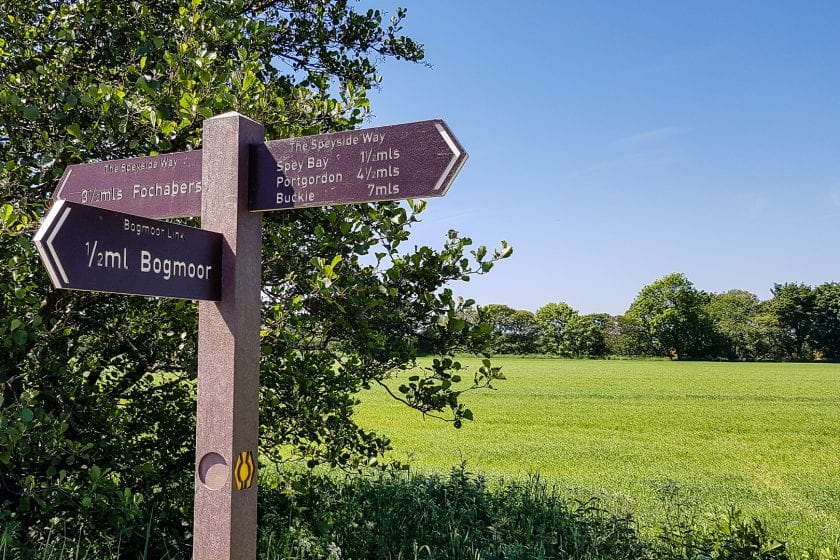
The Speyside Way is fairly well marked, although at times there could be more waymarkers in place. Keep an eye out for wooden posts with an engraved white or yellow thistle symbol. Sometimes signs also say ‘Speyside Way’.
Stage 1: Newtonmore to Kincraig
21km, ~ 4-5 hours + breaks
The first stage of the Speyside Way is pretty long. Some may want to continue as far as Aviemore, but breaking up this route extension in Kincraig is more manageable for most walkers.
Start by following the cycle path from Newtonmore to Kingussie – this is a stage you could easily skip as the two villages are connected by train and bus. From Kingussie, the path heads out to the ruins of Ruthven Barracks and out onto the wetlands of Insh Marshes. The trail then leads through forestry to the scenic Uath Lochans and on to Loch Insh.
Kincraig is a small village. The outdoor activity centre on the edge of the village serves early dinner, but otherwise there aren’t any restaurants, so consider where and how you’ll get your dinner.
Stage 2: Kincraig to Boat of Garten
19km, ~ 5 hours + breaks
From Kincraig it’s about 10 km to Aviemore. The path first follows the river Spey, and then through birchwoods along the railway line. About halfway to Aviemore, make a little detour to Dalraddy Holiday Park where you can find a little coffee truck.
Aviemore is a small town with all the facilities you could ask for. It’s also the original start point of the Speytside Way and where I picked up the trail when I walked it a few years ago.
For lunch, head to Ryvoan Cafe or Route 7 Cafe. After that make your way through light birch-tree woodlands following a broad cycle-friendly track. Every now and then, you’ll see the tracks of the Speyside Strathspey Railway, a historical steam train operating between Aviemore, Boat of Garden and Broomhill.
Soon the birch trees give way to lower shrubs and finally to sparse moorland vegetation with heather, blaeberries and a few lonely pine trees.
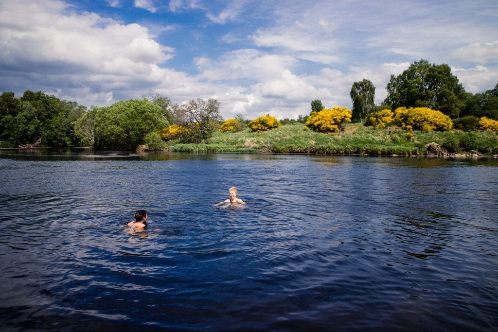
About half-way between Aviemore and Boat of Garten, we made a short detour to pass under the rail tracks and turned right onto a track wide enough to fit a vehicle. We first passed Lochan Dubh (which we could barely see through the trees) and then Loch Dallas which was surrounded by farmland.
We walked past a big farm and finally reached the river Spey at a spot where it did two 90 degree bends. The water was fast flowing, but it was deep enough for a proper swim, and along the shore there were benches and nice patches of grass to rest on.
We took a dive in – brrr, it was cold – and took a long break in the sun to cool down. Rather than walking back to continue on the official Speyside Way, we followed another track along the river, which also led to Boat of Garten.
We reached our accommodation at around 3.30 pm and went straight for a few refreshing beers and a great dinner at The Boat Country Inn and Restaurant.


Stage 3: Boat of Garten to Grantown on Spey
17.5 km, ~ 4.5 hours + breaks
The first section of this section between Boat of Garten and Nethy Bridge leads through a wonderful natural pine forest – some of the last remaining natural Caledonian Pine Forest in Scotland. The footpath is barely wide enough to walk next to each other and runs continuously under the shade of the trees.
Every now and then, a giant gorse bush dips the surroundings in bright yellow – and its flowers smell like coconut!
It took us about two hours to reach Nethy Bridge (7.5 km) mainly because the forest has a lot of inviting rest points, and we walked slowly to keep our eyes open for wildlife.
After lunch in Nethy Bridge, we continued towards Grantown on Spey. The majority of the trail runs along a long-disused railway line and sometimes across farmland. Today the railway line is still a novelty – it means the trail is conveniently wide and the ground fairly flat and easy to walk on.
However, as the Speyside Way continues, you will find that the vegetation along the railway lines is pretty monotonous, and views are often obstructed.
Near Grantown you will have to cross the busy A95 road – take great care! A short detour to Achnagonalin Industrial Estate brings you to KJ’s Bothy Bakery, a fab takeaway for delicious food. Follow a small tarmac road towards the Old Spey Bridge. Here is a good spot for a break, maybe even a dip in the river if you’re brave again. Afterwards, continue on the tarmac road for a little bit, but soon turn right into the Anagach Woods surrounding Grantown.
At a junction, the Speyside Way continues to the right, but to reach Grantown-on-Spey (and your accommodation for the night) go left and into the town!


Stage 4: Grantown on Spey to Ballindalloch
25km, ~ 6 hours + breaks
After picking up lunch at the local supermarket, we backtracked our steps to the junction at the top of Anagach Woods and followed the signs for Speyside Way once again. After an hour of mostly walking flat or downhill through the forest, we reached Cromdale, a small village with little noteworthy going on.
From Cromdale, we continued along another disused railway line, through gorse bushes that overgrow the way, until we have to cross the A95 and the Speyside Way leads into the next forest. The trail now ascends and descends through the woodlands on the slopes of a hill called Tom an Uird. It is sunny again today, so we sweat quite a bit as we climb higher up.
On our way down we meet a couple who had walked the other way from Ballindalloch – we were about halfway and it was time for a lunch break. We had a big group of walkers behind us, so we took an extra leisurely break to make sure we wouldn’t get into each other’s ways. It cost us a bit of time, but it was sunny and the views were lovely!
The rest of today’s route is a section of squeeze-stile gates – we must have gone through at least 40 of them, sometimes three in a row, but who’s counting. The Speyside Way now leads mostly across farmland and through the woods, making for serene views and plenty of encounters with friendly farm animals.
The track climbs steeply quite a few times and our guidebook doesn’t seem to be able to make up its mind, which ascent to call “the hardest section of the trail”. Luckily all the climbs are fairly short and on soft woodland ground so that personally, we didn’t find either of them too hard.
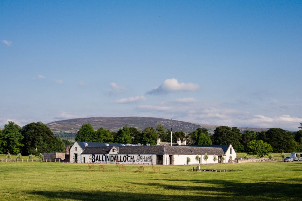
We continued across idyllic farmland until we finally met the river Spey again, and walked the last few miles of the day on a disused railway line next to the river. Once we reached Ballindalloch station near Cragganmore, we left the official Speyside Way trail and followed signs for the Tomintoul Spur.
Our hotel was about 2 miles off the Speyside Way, which doesn’t sound too bad. Unfortunately, though, this section of the Tomintoul Spur leads along the main road, which makes for a rather unpleasant walking experience. I suggest you try to arrange a pickup with your accommodation.
Drink water | This is the longest section of the Speyside Way and it is important that you carry enough water with you! Due to the multiple ascents throughout the day, you will likely drink a lot more than on other days and there are no villages you pass through to fill up. After leaving Cromdale (where you might be able to fill up if you walk a detour to the village) the next drink water supply is at the public toilet at Ballindalloch Station.


Stage 5: Ballindalloch to Craigellachie
19.5km, ~ 5 hours + breaks
Compared to stage 4, stage 5 is super easy – albeit a bit boring. The trail follows exclusively the disused railway line, making for an unexciting trail, apart from a few bridges to cross.
However, today is also when you start walking past some of the famous distilleries of the Speyside whisky region. Unfortunately, most of them are not open to the public, but it is still interesting to see how big and industrial-looking they can be.
Listen to ‘Whisky Galore’ – my Scotland travel podcast about the Malt Whisky Trail!
We had an early lunch at one of the old railway station platforms near a distillery, mended our aching feet with blister plasters and finger tape, and finally reached Aberlour after 4.5 hours.
We had just missed the start of a guided tour at Aberlour Distillery – the only distillery directly on the Speyside Way that offers tours. I recommend booking ahead for the 2.30 pm tour and leave Ballindalloch by 9.30 am in order to make it in time.
However, since our accommodation was in the next village, we decided to book a tour the next morning. To celebrate the plan, we sat down for a long break at the Mash Tun pub and flipped through their overwhelming whisky menu. If you’re a whisky lover, you will want to spend a few hours here!
Our home for the night, Craigellachie, was just another 3.5 km up the railway line, and we reached there around 6 pm. We made a dinner reservation at the local hotel pub (best to call in advance) and moved into our room for the night.


Stage 6: Craigellachie to Fochabers
21km, ~5 hours + breaks
We started the day with a taxi ride back to Aberlour to join the 10 am tour at Aberlour Distillery. The tour lasts around 2.5 hours and includes an extensive tasting session, with a taste of five different Aberlour whiskies: one aged purely in sherry casks, one in bourbon casks, the standard 10-year-old (which blends whisky from bourbon and sherry casks), the pricier 18-year-old and the special cask-strength A’Bunadh edition.
By the time we had picked up lunch from the local Co-op and managed to get a taxi back to the Speyside Way in Craigellachie, it was 1.30 pm. Quite a late start for our second-longest day on the trail!
At first, we were back on the disused railway line, but luckily only for a little while. The Speyside Way soon joined a little tarmac road leading up towards Ben Aigan forest. As soon as you enter the forest, you begin the nicest section today’s trail, along a wide forest road surrounded by large pine trees giving way to gorgeous views every now and then. The trail climbs up and down, almost on the same level as the day before – so don’t expect it to be easy.
After descending towards the river Spey through the forest, you reach Boat o’ Brig – not a village worth mentioning, but a good place to mark the half-way point of today’s walk.
Unfortunately, the walk is quite tough from here – it turns out tarmac roads are worse than disused railway lines. For the next 10 km or so, you walk on tarmac roads, sometimes steeply ascending or descending, but always hard on your joints and the soles of your feet.
We reached our hotel in Fochabers around 7.30 pm and even though we were walking less than the day before, we all agreed that today was by far the hardest section of the Speyside Way!


Stage 7: Fochabers to Buckie
16 km, ~ 4.5 hours + breaks
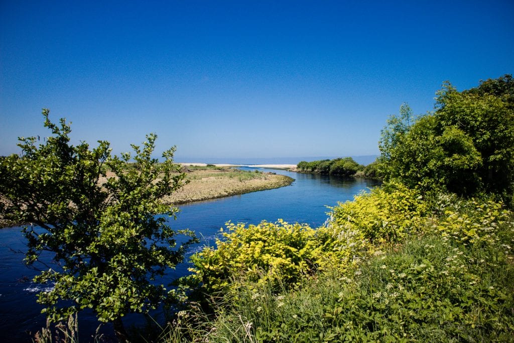
Knowing that it was a short day in terms of miles, we left Fochabers quite late. Stage 7 can be split into two sections which are roughly the same length – 8 km to Spey Bay where the Speyside Way meets the sea, and then another 8 km to Buckie on a joint route with the Moray Coastal Trail.
The first section runs very close to the river Spey, offering beautiful views on a regular basis, and across farmland. Having already spotted the sea yesterday from the top of Ben Aigan forest, we could feel how close we were to the sea now. The air had changed and the vegetation along the trail was different too. And after a couple of hours, we could see it again – the sea.
We reached Spey Bay and took a very leisurely break at the Scottish Dolphin Centre. We had coffee at the cafe and we bought a few souvenirs to take home with us. Mostly, we just sat in the sun and explored the white pebble beach, listening to the waves rolling and crashing.
The last section of the Speyside Way is like a leisurely stroll, first through a tall pine tree forest and then along the shore following the Moray Coastal Trail. We were not lucky in spotting any bottle-nose dolphins around Spey Bay, but were excited when we encountered a local seal colony near Portgordon.
Eventually, we reached Buckpool, the part of Buckie where the Speyside Way officially ends. The last kilometres were on tarmac again and we couldn’t find the sign that marked the end of the trail. Tired and thirsty (for beer), we did not fuss around for long and continued to the centre of Buckie, where we first checked into our hotel and then went for drinks at a local pub.
But what can I say – after 6 days of tranquil country towns and villages, serene nature and pristine wildlife spotting, Buckie was a bit of a disappointment. Its days as a bustling fishing town were long gone. Many of the storage halls and fish factories by the harbour were desolate and falling apart. The nicer of the two pubs was OK, but not what you’d wish for on a sunny day after a 65-mile trek (aka. somewhere with a nice beer garden).
I think Buckie is an OK overnight stop at the end of the Speyside Way, but if I planned it all again, I’d get on a bus to Cullen, Banff, Elgin or Inverness as soon as I finished a celebratory pint in Buckie!
You might also like: 20 pretty villages and towns in Scotland


Where to stay on the Speyside Way
There is lots of accommodation in the Speyside region, but walking without a support vehicle limited our choices significantly.
It was not always easy finding available accommodation at the end of each stage – particularly in Ballindalloch, we struggled. Ironically. the hotel we eventually found just 2 miles off the trail, was our favourite hotel on the Speyside Way!
We stayed in a variety of hostels, hotels, B&Bs and bunkhouses in Aviemore, Boat of Garten, Grantown on Spey, Ballindalloch, Craigellachie, Fochabers, and Buckie.
Travelling in a group of three, we chose accommodation that could offer three/four-bed or family rooms and tried to book places that included breakfast.
Head over to my post about our Speyside Way accommodation for a full list of recommended places to stay.

Distilleries along the Speyside Way
The Speyside whisky region is famed for having the highest density of whisky distilleries per square mile: there are over 50 Speyside whisky distilleries! Many of them are open to the public and offer guided tours and tasting sessions, however only one of them lies directly on the Speyside Way.
While you will pass many distilleries on the Speyside Way, for example, Tamdhu, Knockandoo or Cragganmore, only Aberlour Distillery offers tours for visitors. Since it is a popular distillery with only two tours per day, I highly recommend booking in advance!
One thing to keep in mind is to look into the ownership of whisky distilleries. There are still many independently owned distilleries all over Scotland, as well as small family- or community-run distillery groups, however, many distilleries are owned by large international concerns. Aberlour for example, is part of Pernod Ricard, the world’s second-largest wine and spirits seller.
Independent or Scottish-owned Speyside distilleries near the Speyside Way include Ballindalloch near Ballindalloch station, Balvenie in Dufftown, Glenfiddich in Dufftown, Macallan near Craigellachie and the Speyside Distillery near Kingussie. They all welcome visitors for tours and tastings.
I recommend planning an additional day to visit one or more of these distilleries, and organise transfers with a local taxi company or a private tour agency.
You might also like: The essential guide to trying Scottish whisky

Vegan food along the Speyside Way
Travelling Scotland as a vegan is easy, but just like with accommodation and distilleries, walking the Speyside Way means you only really have access to what is directly along the route.
Luckily, there are plenty of restaurants and hotels along the Speyside Way that are happy to accommodate vegan hikers. Co-op supermarkets are also well equipped and you can easily pick up lunch supplies and snacks in most villages along the way.
Check out my full guide to vegan-friendly food along the Speyside Way for specific recommendations for restaurants and cafes.

Speyside Way Packing List
As I mentioned earlier, we were carrying everything we needed along the Speyside Way on our backs, since we did not want to splurge on baggage transfer. Luckily, you won’t require too much stuff along the way, particularly if you’re not camping and are happy to share a few essentials with your friends.
I stuck to my trusted long-distance hiking packing list, which has served me well so far on the West Highland Way, the King’s Trail in Sweden and the West Island Way. Here is a quick overview of what I packed – for more detail, concrete product recommendations and the contents of my toiletry & first aid kit, consider my full list (linked below)!
40L hiking backpack
1L bottle of water
3L drinking system
Pair of sturdy hiking boots
4 tops (2 hiking, 1 evening, 1 sleeping)
2 bottoms (1 hiking, 1 leggings)
1 fleece cardigan waterproofs (jacket and trousers)
1 bathing suit + travel towel
1 buff underwear + 2 bras (1 sport, 1 normal)
3 pairs of socks (2 hiking, 1 normal)
Light-weight trainers
Toiletries
First aid kit
Sun lotion
Sunglasses
Small, sharp knife
Camping stove + pot + gas + matches
Toilet paper + matches
Small cup
Whisky flask
Speyside Way guidebook ,map + pen
Camera + batteries + charger
You might also like: How to pack for long-distance hiking in Scotland
The Speyside Way is a brilliant long-distance trail in Scotland – it is not as popular and busy as the West Highland Way, but it offers the same amount of stunning scenery and traditional Scottish encounters.
If you’re into your Speyside whisky or want to travel through Scotland off the beaten track on your own speed, I can’t recommend walking the Speyside Way enough. This full hiking guide to the Speyside Way has included all the information necessary to plan a successful trekking holiday in Scotland!
Have I convinced you to hike the Speyside Way on your next Scotland holiday?
Pin this post for later:


Hi,
Great blog,will be really useful helping us plan the walk in 2020.
A couple of questions if I may. Any midge season as per The West Highland Way (June/July/August) to avoid?
and
Being of a certain age, if contact with the outside world is required, or just calling ahead for a pick up, any networks that either worked for you or can recommend?
Thanks for adding to the anticipation.
Hi Brian, midge season is pretty much the same on the Hebrides, although I must say that I hardly had any because I hiked right after a very long and hot dryspell. I had more issues with black flies (just annoying) and horse flies (painful bites), but even those were minimal on the islands. Wind is on your side especially on days where you hike next to the coast, as midges can’t cope with it. I’d still go in the summer months, as it can be quite chilly to camp up there out of season. I use Three for my mobile phone and found I had pretty good coverage. Not so much in the hills, but it was decent enough. You’re generally never too far from civilisation and I”m sure people would let you use their landline phone in an emergency. I hope you have a great trip!!
This looks amazing! I am not sure I could hike for that long but it sure looks pretty and I like the idea of hiking but spending the night in a cozy bed 😉 As for someone who unfortunately doesn’t like whisky – what are my chances of finding a gin distillery on the way??
Oooooh, of course! There’s plenty of gin made in that area too! Coarunn near Grantown is basically on the way and I’m quite sure they do tours! Love that gin 😀
Thanks so much for this!! We’re heading to Scotland next month so will definitely do this.
Even just a section of it is so worth it!!
This is such a fantastic route. I loved following your IG stories on this one. It’s certainly been added to the list.
Beautiful pictures! I love long hikes, I’ve never done one quite this long, but I hope I can give it a try someday!
It’s such an amazing challenge to push yourself just that little bit further with every hike! I’ve got a 2-week trail lined up next – let’s see how I get on!!
I’ve never heard of this hike but it’s on my list now — great photos!
I am totally convinced! Each stage looks absolutely gorgeous. Plus this is honestly the most thorough and useful guide I’ve ever read, so saving for when that day comes! Thanks for sharing!
Thanks! I hope it will be useful once you get to come and do the Speyside Way yourself!
Now, you probably already knew that I am no hiker but I loved your updates from this adventure on Instagram and Facebook and blimey, this is a monster of a helpful post, so much so, even I would maybe think about doing this one day. Also, that bee photo is so beautiful!
Thank you!! It’s a great hike, and you can do it in stages or get your luggage transported for you! Even just doing a part of it might be a rewarding idea for a family holiday 🙂
I’ve walked the West Highland Way and had no idea this trail existed! It’s now on my list and I have your guide to help me out! Gorgeous photos!!
Thank you! It’s very different landscape-wise, but still sooooo beautiful! Worth the trek – literally!
Amazing pictures and trekking! love it very much.